Northumberland has one of the densest concentrations of prehistoric rock art in Europe. Across the moorlands and hilltops of the county — from the Cheviot Hills to the coastal sandstone ridges — thousands of cup-and-ring marks are carved into exposed rock surfaces. They were made between four and six thousand years ago, in the Neolithic and Bronze Age, by people whose names, language, and beliefs are entirely lost. Nobody knows what the carvings mean. Nobody knows why they were made. They are, in the most literal sense, a mystery written in stone.
The Carvings
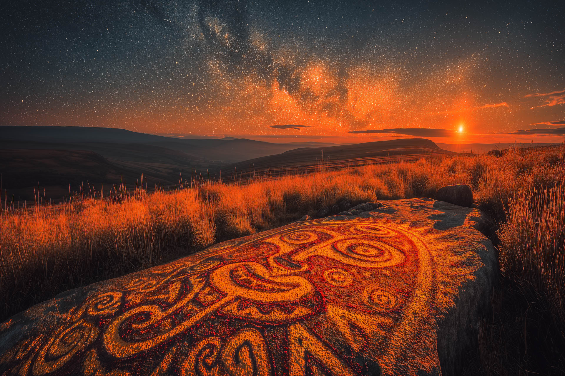
Cup-and-ring marks are exactly what they sound like: circular hollows pecked into the surface of sandstone or whinstone, sometimes surrounded by one or more concentric rings, sometimes connected by channels or grooves. The simplest are single cups — depressions no bigger than a thumbnail. The most complex are elaborate patterns of interlocking rings, spirals, and channels covering entire rock faces. They appear across northern and western Britain, from Cornwall to Orkney, but nowhere in greater concentration than in Northumberland.
The Cheviot Hills alone contain more scheduled ancient monuments per square mile than almost anywhere in England. The carvings sit on open hillsides, on outcrops above valleys, on boulders beside ancient trackways. Some are immediately visible. Others are hidden by heather and bracken and can only be found with a map, patience, and low winter sunlight that throws the carvings into shadow. They were almost certainly meant to be seen — but by whom, and for what purpose, remains unknown.
The Key Sites
Lordenshaws
Over 100 carvings spread across a moorland hillside above Rothbury, combined with an Iron Age hillfort. Panoramic views across Coquetdale. One of the most accessible and atmospheric rock art sites in Britain. Free, open access.
Roughting Linn
The largest decorated rock in northern England — a single outcrop measuring approximately 20 metres by 12 metres, covered in cups, rings, and channels. Stan Beckensall called it one of the finest rock art panels in the world. A waterfall nearby adds to the drama. Free, open access.
Old Bewick
Home to the biggest cup mark in the world. This is the site where rock art was first recognised as man-made rather than natural erosion. The hillfort dates to around 350 BC. Remote, rarely visited, and extraordinary. Free, open access.
Duddo Five Stones
A stone circle approximately 4,000 years old, standing on a low ridge with views in every direction. The five surviving stones are deeply weathered into extraordinary grooved shapes. One of the most photogenic ancient sites in England. Free, open access, short walk from the road.
Brough Law
An Iron Age hillfort measuring 68 metres by 54 metres, with three or more hut circles visible inside the walls. Occupied for over a thousand years. Sits on a prominent hilltop in the Breamish Valley with commanding views of the Cheviots. Free, open access.
Ingram & Breamish Valley
Britain's greatest concentration of Iron Age hillforts. The valley contains more fortified settlements per mile than almost anywhere in the country. The Votadini tribe — who also fortified Bamburgh around 800 BC — controlled this territory for centuries.
Stan Beckensall — The Man Who Found Them
No account of Northumberland's rock art is complete without Stan Beckensall. A schoolteacher turned archaeologist, Beckensall spent decades walking the hills of Northumberland, documenting hundreds of carved panels that had been overlooked, forgotten, or simply never recorded. His books — including Prehistoric Rock Art of Northumberland and Northumberland's Hidden History — are the essential guides to the county's ancient landscape. He did not just record what he found; he made the case that Northumberland's rock art was of international importance, equal in significance to sites in Galicia, Ireland, and Scandinavia. He was right.
These carvings were not random. They were placed with care, in positions that commanded views, overlooked water, or marked routes through the landscape. The people who made them understood their world profoundly. — Stan Beckensall, on the purpose of Northumberland's rock art
The Iron Age
By the first millennium BC, the hilltops of Northumberland were crowned with forts. The Iron Age people of the Cheviots — part of the tribal confederation known to the Romans as the Votadini — built hundreds of enclosed settlements across the uplands. Some were substantial hillforts with stone walls, ditches, and multiple roundhouses. Others were smaller farmsteads with palisade enclosures. The Breamish and Ingram valleys alone contain an extraordinary density of these sites, many of them visible from each other across the open moorland.
The Votadini were not a primitive people. They farmed, traded, and maintained complex social structures. They fortified Bamburgh around 800 BC — centuries before the Anglo-Saxons arrived. When the Romans came, the Votadini appear to have become allies rather than enemies, and their territory may have formed the basis of the later kingdom of Gododdin. The famous Old Welsh poem Y Gododdin — one of the earliest surviving works of British literature — describes a war band from Edinburgh riding south to fight the Angles. Many scholars believe the warriors came from Votadini lands that included what is now Northumberland.
Yeavering Bell — A Hilltop Town
Above the village of Kirknewton, near Wooler, the twin-peaked hill called Yeavering Bell holds the largest hillfort in northern England. At 5.6 hectares — roughly nine football pitches — it dwarfs every other fortified settlement in the region. Archaeologists have identified the platforms of at least 125 roundhouses inside the collapsed stone ramparts, and there may have been more. If they were all occupied at once, up to a thousand people could have lived here. This was not a defended farmstead. It was a town.
Two of those roundhouses were larger than the rest, positioned either side of the main southern gateway. Researchers including Oswald, Ainsworth and Pearson have noted that in the entire Iron Age record of northern Britain, Yeavering Bell is almost the only site where the residences of powerful individuals — rulers, druids, warriors — can be tentatively identified from the surface evidence alone. Whether this was the capital of the Votadini, or something else entirely, is still debated. But something significant happened on this hilltop.
There are details that stay with you. The oldest recorded name for the hill — Gefrin — is believed to derive from a Celtic word for goat. Wild goats still roam the slopes today. On the eastern summit, a Bronze Age burial cairn predates the hillfort by perhaps two thousand years. Did the Iron Age people who built their walls around it revere the person buried inside? Did they treat the mound as a shrine? Nobody knows. But they chose to build their largest settlement around it, and that is unlikely to be coincidence.
On a clear day from the summit you can see Eildon Hill North, over sixty kilometres away in the Scottish Borders — another giant hillfort of similar size. Whether the people on the two hilltops knew of each other, traded with each other, or fought each other is a question that archaeology has not yet answered. But the view alone is worth the climb. What you make of the rest — the tumbled ramparts, the house platforms, the goats — is between you and the hill.
Lordenshaws — Where the Carvings Meet the Fort
Lordenshaws is the place where two different periods of Northumberland’s prehistory sit on top of each other. The hillfort — Iron Age, perhaps around 500 BC — occupies the higher ground. The rock art — Neolithic and Bronze Age, far older — covers the outcrops on the surrounding slopes. The people who built the fort knew the carvings were there. In some cases, they broke up the carved stones and used them in their rampart walls. In others, they appear to have left them alone, perhaps out of respect for something they did not fully understand but recognised as important.
What the English Heritage survey by Oswald, Ainsworth and Pearson revealed is that Lordenshaws is not one site but many, layered on top of each other across thousands of years. The hillfort itself went through multiple phases of construction. In the Roman Iron Age, small rooms were built into the old rampart — perhaps storage, perhaps shelter. Three trackways approached the enclosure from different directions, suggesting it remained a gathering point long after the original fort fell into ruin. The landscape around it is scattered with clearance cairns, field boundaries, and the faint traces of ancient agriculture. This was a worked, lived-in, contested landscape — not the empty moorland it appears to be today.
We walked up to Lordenshaws recently and found one carved stone. There are over a hundred. Low winter light is the key — it throws the shallow carvings into sharp relief. In summer they can be almost invisible. Go back in December, late afternoon, with the sun at your ankles. You will find things you did not see before.
The Mystery
Nobody knows what the cup-and-ring marks mean. Theories abound: maps of territory, astronomical observations, markers for sacred sites, territorial boundaries, symbols of fertility, representations of water or sound. Some researchers have noted that many carved panels face south or east. Others have observed that they cluster near water sources, trackways, or significant viewpoints. The honest answer is that we do not know, and we may never know. The people who carved them left no written record, no oral tradition that survived, and no key to their symbols.
That mystery is part of their power. To stand at Lordenshaws on a winter afternoon, with the light low and the carvings sharp in the slanting sun, is to confront six thousand years of human presence in a landscape that has barely changed. The heather is the same. The view is the same. The wind is the same. Only the meaning has been lost.
Six Thousand Years
Finding the Sites
Most sites are unmarked. You will need an Ordnance Survey map (Explorer OL16 for the Cheviots, OL42 for Kielder and Redesdale) and a willingness to walk across open moorland. Footpaths exist to the major sites but signage is minimal.
Best conditions: Low winter sunlight throws the carvings into sharp relief. Summer visits in flat light can make the marks almost invisible. Early morning or late afternoon is ideal.
Lordenshaws is the most accessible — a short walk from a roadside car park near Rothbury. Roughting Linn requires a longer walk but is well worth the effort. Old Bewick and the Breamish Valley hillforts require map-reading skills and boots.
Duddo Five Stones is reached by a short walk across a farm field — signposted from the road near Duddo village.
All sites are free, open access, and on public land or rights of way. Respect the archaeology — never make rubbings, chalk the carvings, or remove any material from the sites.
Further Reading
Hillforts: Prehistoric Strongholds of Northumberland National Park — Al Oswald, Stewart Ainsworth & Trevor Pearson (English Heritage, 2006). The definitive archaeological survey of Northumberland’s hillforts, based on a five-year programme of fieldwork funded by the EU and Heritage Lottery Fund. Covers Yeavering Bell, Lordenshaws, Brough Law, Wether Hill, and dozens of lesser-known sites in extraordinary detail. If anything on this page has caught your attention, this is the book to find next.
Prehistoric Rock Art of Northumberland & Northumberland’s Hidden History — Stan Beckensall. The essential field guides to the county’s rock art, written by the man who spent decades documenting it.